Cymraeg / English

|
Middle Usk Valley Historic Landscape |

|
Character area map |
|
|
More photographs |
Historic Landscape Characterisation
The Middle Usk Valley:
Pen-y-crug
Brecon, Honddu Isaf and Ysgir communities, Powys
(HLCA 1171)
Diverse, undulating landscape to the north and west of Brecon with predominantly irregular fields, and areas of conifer woodland and unenclosed hilltop common, broken by small stream valleys. Prehistoric and Roman defensive structures including the large Pen-y-crug and Coed Fenni-fach Iron Age hillforts and Brecon Gaer Roman fort. Significant elements of transport history including the Roman road network focused on Brecon Gaer and the later 19th-century Neath and Brecon Railway.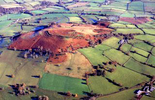
Historic background
The dating of the prominent standing stones at Battle and Cradoc is uncertain, though they may possibly be of Bronze Age date. Early settlement and land use is indicated by the Pen-y-crug and Coed Fenni-fach Iron Age hillforts and by the Roman fort and associated Roman civilian settlement at Brecon Gaer, dating from the conquest period in about AD 75.In the early medieval period the area formed part of Cantref Selyf within the kingdom of Brycheiniog, which following the Norman conquest formed part of the marcher lordship of Brecon. The fall of the native kingdom, marked by the battle between Bleddyn ap Maenarch and Rhys ap Tewdwr and Bernard de Newmarché in 1093 which is traditionally held to have taken place in the fields to the south of the village of Battle, but this is in fact named after Battle Abbey in Sussex, which drew income from the parish here. The church at Battle, dedicated to St Cynog and first documented in the 1220s, was a dependent chapel of Brecon Priory.
Following the Act of Union in 1536 the area later formed part of Merthyr Hundred within the county of Brecknock. It subsequently formed parts of the 19th-century tithe parishes of Brecon St John and Battle.
Key historic landscape characteristics
Predominantly medium to large-sized irregular fields with hedged boundaries, between a height of 140-310 metres above sea level, representing piecemeal enclosure from at least medieval times. Smaller, discrete areas of straight-sided fields suggesting enclosure or landscape reorganisation in the post-medieval period, with an area of rough, unimproved common land pasture on Pen-y-crug. Woodland at Coed Fenni-fach and along the north bank of the river Usk including some semi-natural and replanted broadleaved woodland and conifer plantations probably of the later 18th to 20th centuries.Later prehistoric settlement and land use in the area is indicated by the two large and strategically-sited hillforts at Pen-y-crug and Coed Fenni-fach which probably represent Iron Age tribal centres associated with the native tribe known as the Silures.
The characteristic Roman fort at Brecon Gaer was constructed in the conquest period following the subjugation of the native tribe known as the Silures in about AD 75, stone defences being added in the earlier 2nd century and a civilian settlement becoming attached to the fort. The fort’s garrison appears to have been reduced in size by about the middle of the 2nd century though there is evidence of continued activity of some kind, possibly of a civilian nature, continuing into at least the later 4th century. A cropmark enclosure site about 300 metres to the west of Brecon Gaer may represent a Roman military practice camp.
Brecon Gaer lay at the hub of a system of strategic military Roman roads, running southwards in the direction of Ystradgynlais (Powys), northwards towards Llandrindod, south-eastwards along the Usk valley to Abergavenny (Monmouthshire), north-eastwards to Kenchester (Herefordshire) and south-westwards to Llandovery (Carmarthenshire). Inscribed Roman milestones indicate that the road between Brecon Gaer and Llandovery was maintained into at least the later 3rd century and the road between Brecon Gaer and Abergavenny up to at least about the middle of the 4th century. Parts of the course of each of these roads are known from fieldwork or excavation though other stretches are speculative.
Modern settlement is represented by the small nucleated church settlement of medieval origin at Battle, the small nucleated settlement which appears to have grown up at road junctions or bridge crossings as at Cradoc and Pont-yr-Ysgir in the post-medieval period, and by relatively large and dispersed farms with other scattered houses and cottages elsewhere, some of which may originate in the medieval period. An earlier phase of gentry houses is represented by Gaer House farmhouse, probably 16th-century timber-framed building to which a stone-built wing was added later. At Pen-y-crug is a characteristic later 18th and early 19th-century stone-built complex including a farmhouse, barn, cowhouse and wood store. Lake House is a later 19th-century rendered stone villa on western shore of Gludy Lake, built in a Swiss or Alpine cottage style.
Industrial activity in the area is represented by scattered former small stone quarries for building stone and by the former brick and tile works on the southern slopes of Pen-y-crug hillfort which probably supplied the expanding town of Brecon with building materials in the late 18th- and earlier 19th-century, going out of use once building materials could be supplied to Brecon by rail, from the 1860s onwards.
The dismantled course of the Neath and Brecon Railway line, completed by 1872 and closed in 1963, line crosses the northern side of the area.
Sources
CPAT Regional HER; Cadw Listed Buildings database; Charles 1938; Burnham 1995; Casey 1970; Craster 1954; Davies 1981; Davies 1999; Fenton 1917; Glynne 1886; Haslam 1979; Hogg 1965; Jarrett 1969; Jones 1909; King 1959; Jones and Smith 1965; Lewis 1833; Martin and Walters 1993; Maxwell and Wilson 1987; Morgan and Powell 1999; Parry 1985; RCAHMW 1997; Rivet and Smith 1979; Silvester and Dorling 1993; Wheeler 1926; Waller 2000For further information please contact the Clwyd-Powys Archaeological Trust at this address, or link to the Countryside Council for Wales' web site at www.ccw.gov.uk.
Privacy and cookies