Cymraeg / English

|
Middle Usk Valley Historic Landscape |

|
Character area map |
|
|
More photographs |
Historic Landscape Characterisation
The Middle Usk Valley:
Pencelli-Talybont
Brecon, Llanfrynach and Talybont-on-Usk communities, Powys
(HLCA 1175)
Large irregular, low-lying fieldscape probably representing relatively late enclosure of former common meadows on the broad alluvial floodplain of the Usk between Brecon and Talybont-on-Usk, with complex and active system of river meanders and cutoffs, crossed by the Monmouthshire and Brecon Canal, and including the small nucleated settlements of medieval origin at Llanfrynach, Pencelli, and Talybont-on-Usk. Significant Roman villa complex at Maesderwen near Llanfrynach.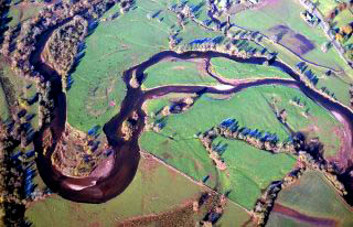
Historic background
Early prehistoric settlement and land use is suggested by the possibly Bronze Age Gileston standing stone, about 300 metres from the south bank of the river Usk and probable Bronze Age Cae Gwin barrow with stone cist, north-east of Llanfrynach. Later prehistoric settlement and land use is indicated by the Cross Oak hillfort, north of Talybont-on-Usk.The line of the Roman road between Abergavenny and Brecon Gaer is assumed to fall along either the A40 or the B4558 roads which bound the northern and southern sides of the area respectively. A substantial high-status Roman civilian complex of the early 3rd to later 4th century, with decorated mosaic floors, is known at Maesderwen, just to the west of Llanfrynach, which may have formed to focus of a large privately-owned estate. Roman ironworking also appears to have been undertaken within the area.
The area formed part of the eastern edge of the cantrefs of Cantref Selyf to the north of the Usk and Cantref Mawr to the south and subsequently part of Pencelli Hundred, and parts of the 19th-century tithe parishes of Llansantffraed, Llanfeugan, Llanfrynach and Brecon St David.
Later medieval and early post-medieval settlement is indicated by the Tower, Scethrog, probably part of a 16th-century fortified tower house, built by a branch of the Pichard family.
Key historic landscape characteristics
Predominantly large irregular, low-lying fields with hedged boundaries generally on the flat valley bottom bordering the meandering river Usk possibly representing late medieval or post-medieval enclosure of former common meadows, between a height of 120-60 metres above sea level. Modern land use is predominantly pasture.Modern settlement is largely confined to the three small nucleated settlements at Llanfrynach, Pencelli and Talybont-on-Usk. Llanfrynach comprises several substantial farms, rows of terraced cottages, public house and Baptist chapel. The medieval parish church, largely rebuilt in the later 19th century, is dedicated to the local early medieval saint Brynach. It lies within a very large curvilinear churchyard and is associated with a pre-Conquest cross slab of the 10th/11th century. The small modern settlement at Pencelli largely owes its existence to the road and canal which passes through it, though it probably originated as a dependent settlement associated with Pencelli Castle. The castle, which probably formed the focus of a medieval manorial estate, was in existence by the early 13th century and evidently remained in good repair until the late 15th century. Talybont-on-Usk is likely to owe its origin to the medieval bridge across the river Caerfanell in existence by the 14th century. It expanded as a small industrial and commercial centre along the Monmouthshire and Brecon Canal, acting as a transfer point for coal and limestone brought from the south by way of the Brinore Tramroad, built in 1814–15 and the Brecon and Merthyr Railway during the later 19th century. The settlement includes a number of substantial 17th and 18th-century houses, the White Hart Inn, a late 18th to early 19th-century inn, and a Methodist chapel. Structures associated with the settlement’s industrial and transport history include a bank of stone-built former limekilns alongside the canal and beneath the Brinore tramroad, possible remains of station buildings and offices associated with the tramroad, an aqueduct carrying the canal across the Caerfanell and a railway bridge crossing the B4558. The more dispersed settlement at Llanhamlach may represent a shrunken settlement originally focused upon a medieval manorial centre superseded by Peterstone Court and associated with a proprietary church, but the modern settlement pattern is influenced by the late 18th to early 19th-century Abergavenny to Brecon turnpike road on the course of the modern A40.
Significant features associated with the Monmouthshire and Brecon Canal include the early 19th-century stone aqueduct of four arches and two cutwaters at Cefn Brynich which carries the canal across the river Usk, near the probably 18th-century stone-built Lock Road Bridge with its four massive arches and cutwaters. A number of the original stone humpbacked canal bridges survive on the stretch of road between Talybont-on-Usk and Pencelli though others were lowered and replaced by concrete bridges in the 1950s and 1960s. There are also a number of steel lift bridges of which at least some were repaired or replaced during the 20th century. There are small groups of 19th-century canal cottages to the north-west of Talybont. Other industrial remains include the important intact water-powered Gileston corn mill and mill-house. The mill structure which is probably of 17th century origin, has surviving 18th and early 19th-century machinery, making it one of the best-preserved example of watermill in Brecknock.
Notable elements of designed landscapes include the former parkland associated with Peterstone Court and the series of post-medieval formal walled garden enclosures, ponds and water channels around the secluded fine late seventeenth-century manor house adjacent to the river flood plain at Abercynrig, near the confluence of the Afon Cynrig and Usk. The house is associated with a complex of well-preserved farm buildings arranged around a yard including stables, former cider mill and dovecote.
Sources
CCW SSSI citation; CPAT Historic Environment Record; Cadw Listed Buildings Lists; Charles 1938; Davies 1992; Emery 2000; Hay 1785; Hogg and King 1967; Hughes 1990; Jones and Owen 2000; Jones and Smith 1965; King 1961; Morgan and Powell 1999; Nash-Williams 1948-50; RCAHMW 1988; Silvester and Dorling 1993For further information please contact the Clwyd-Powys Archaeological Trust at this address, or link to the Countryside Council for Wales' web site at www.ccw.gov.uk.
Privacy and cookies