Cymraeg / English

|
Caersws Basin Historic Landscape |

|
Character area map |
|
|
More photographs |
Historic Landscape Characterisation
The Caersws Basin:
Llanwnog
Caersws community, Powys
(HLCA 1179)
Some evidence of early prehistoric settlement and land use. Course of Roman road north of the Roman fort at Caersws. Mixed fieldscapes representing both piecemeal clearance and enclosure and the probable enclosure of former medieval open fields associated with the nucleated settlement of early medieval or medieval origin at Llanwnog. Industrial hamlet exploiting water power at Pontdolgoch, and features associated with the development of the turnpike road and railway networks in the 18th and 19th centuries.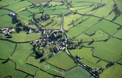
Historic background
The area fell within the manorial townships of Escob and Castle, Wig, and Surnant in the Montgomeryshire tithe parish of Llanwnog. The name of Llanwnog is first recorded in the late 12th century and has the meaning ‘church of Gwynnog’, the saint to whom the church, like that at neighbouring Aberhafesp, is dedicated. In the early 14th century the bishop of Bangor held lands in the parish.Key historic landscape characteristics
Mixed lowland fieldscapes on the valley bottom and lower hill slopes of the lower valley of the river Garno, between a height of 130-240 metres with several low hillocks in the area between Llanwnog and Caersws representing glacial drumlins which have affected local drainage patterns. There is some variation in soil types in the area which historically had had an impact upon economic potential. Bordering the river Garno are deep stoneless alluvial permeable silty soils, suited to dairying and stock rearing on permanent and short-term grassland and cereals. Around Llanwnog is an area of well-drained, fine loamy and silty soils overlying shale bedrock or fluviglacial deposits, suited to dairying and cereal. Along the lower Manthrig Brook between Llanwnog and Caersws are deep, stoneless, fine silty and clayey alluvial soils affected by waterlogging, which are best suited to dairying and stock rearing on permanent pasture. Fieldscapes are predominantly composed of both large and small irregular fields probably representing piecemeal clearance and enclosure from medieval or earlier times though there is a distinctive and relatively extensive patterns of strip fields to the west and south of the village of Llanwnog which appear to represent medieval open fields which had been enclosed in perhaps the later medieval and early post-medieval periods. Some small-scale reorganisation of field boundaries evidently took place to the south of Pontdolgoch at the time the Newtown to Machynlleth railway was constructed in the late 1850s.A majority of the placenames are associated with settlement, industry and communications including, for example, the element gefail (‘smithy’) in Rhiw-yr-efail, plas (‘hall’) in Henblas, pont (‘bridge’) in Pontdolgoch and wtra (‘lane’) in Ty’n-yr-wtra. Meadow land is suggested by the element dol in Pontdolgoch and woodland by the element gwig ‘wood, grove’ in Wig, first recorded in the later 16th century, towards the western side of the area. An ecclesiastical landholding, presumably belonging to the bishop of Bangor, is indicated by element esgob (‘bishop’) in Parc-yr-esgob just to the north of Llanwnog, which is first recorded in the mid 16th century and formed an element of the name of the township of Escob and Castle in the parish of Llanwnog.
Significant evidence of early prehistoric settlement and land use is provided by a scatter of chance finds along the Garno including a perforated macehead found at Pontdolgoch, a fragment of early Neolithic pottery from near Blackhall Cottages, and possibly two ring-ditches representing burial monuments in the area between Blackhall Cottages and Llanwnog. A buried burnt mound close to the bank of the Garno just to the west of Wig bridge is perhaps of Bronze Age date.
The course of the Roman road leading from the north gate of the Roman fort is thought to run along the Garno valley more or less along the line of the A470 but has yet to be identified where it crosses the character area.
The small nucleated settlement at Llanwnog came into being in the early medieval or medieval period, and together with Llandinam south of the river Severn eclipsed the earlier administrative centre of the region which focused upon the Roman fort at Caersws. Although its origins are as yet obscure, the suggestion of former open field arable farming particularly to the west and south of the village centre and its association with a medieval church may suggest that it may have come to form an early manorial centre. Open fields are suggested by reasonably distinct patterns of long, elongated strip-like patterns of fields, some of which are still associated with relict traces of broad ridge and furrow. The church, dedicated to St Gwynnog, is first documented in the mid 13th century, but its siting within a curvilinear churchyard, which together with the llan (‘enclosure’) element in the placename suggests a possible foundation in the 8th to 9th century. Some of the surviving medieval fabric of the church is constructed of squared blocks of sandstone which are thought to have been taken from the defences of the Roman fort at Caersws. The fine medieval rood screen and loft and fragments of medieval window glass including an image of St Gwynnog hints at some form of patronage.
Most early buildings up to the earlier post-medieval period were probably of half-timbered construction. Surviving smaller buildings of 17th century date within the area include the cottage within the village of Llanwnong dated 1664 and a cottage in Pontdolgoch. The larger, higher status timber house at Perth-eiryn, just south of Pontdolgoch, to which a brick front was added in the 18th century, is one of a number of isolated lowland gentry houses in the historic landscape area. These appear to indicate the development of estate centres in the open countryside in the 16th and 17th centuries, possibly in association with the enclosure of lowland common meadows bordering the Severn and its principal tributaries that was taking place at this period.
The village of Llanwnog continued to develop in piecemeal fashion in the post-medieval period, its character strongly influenced by the presence of a series of farms which emphasise its agricultural origins and was influenced by the development of the turnpike road network in the later 18th and early 19th centuries, when new bridges were constructed across the Garno at Wig and at Pontdolgoch. The area to the north-east of the village expanded with modern housing development and rural roadside houses in the 20th century. The hamlet at Pontdolgoch, which may have originated in the Middle Ages, expanded with the exploitation of the power of the river Garno between the 17th and 19th centuries when a sawmill, corn mill and woollen mill were built, associated with mill leats, millponds, mill houses and workers cottages. A smithy, roadside inn and nonconformist chapel had been added to the settlement by the mid 19th century. The water-driven sawmill remains operational. Another woollen mill which is no longer extant was built further downstream near Wig Bridge. With the coming of the railway in the early 1860s railway bridges were built across the road and river at Pontdolgoch. The railway is still operational but the former station and stationmaster’s house at Pontdolgoch have now been converted to domestic use.
Some development of rural farms continued into the 20th century probably under the influence of a number of the larger estates. There is also an important series of early county council smallholdings in the area, as at Maesteg, Wig Lane, Caersws.
Bombs are said to have been inadvertently dropped on part of the village of Llanwnog as a result of enemy action during the course of the second world war.
Sources
Historic Environment Record; Cadw Listed Building descriptions; modern Ordnance Survey 1:10,000, 1:25,000 mapping and 1st edn Ordnance Survey 1:2,500 mapping; Anthony 1995; Barker 1997; Barton 1997; Barton 2003; Baughan 1980; Crossley and Ridgway 1947; Davies 1810; Davies 1829; Dempsey 1997; Eisel 1986; Ellis 1838; Gibson 1997; Gibson 1998; Haslam 1979; Howell 1875; Jenkins 1969; Lewis 1833; Lunt 1986; Owen 1957-58; Morgan 2001; Parry 1998; Pennant 1783; Price 1998; Pryce 1886; Putnam 1961-62; RCAHMW 1911; Silvester 1992; Silvester 2003; Silvester 2004; Silvester and Hankinson 2002; Silvester and Hankinson 2003; Silvester and Owen 2004; Smith 1975; Stephenson 2005; Walker 1871For further information please contact the Clwyd-Powys Archaeological Trust at this address, or link to the Countryside Council for Wales' web site at www.ccw.gov.uk.
Privacy and cookies