|
 Fields and farms around the margins of the reservoirs
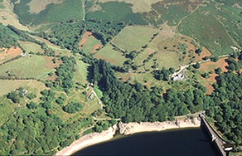
Enclosed fields near Alltgoch and Penygarreg farm with Penygarreg dam in the foreground. The course of the former railway up to Craig Goch dam runs along the far bank of the reservoir.
Photo: CPAT 03-C-0616.
|
|
|

|
|
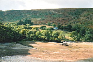 Enclosed fields near Tynllidiart farm, on west bank of Garreg-ddu reservoir, with Moelfryn on the horizon. Old field banks are visible along the shore line of the reservoir during a period of low water.
Photo: CPAT 1527.26.
Enclosed fields near Tynllidiart farm, on west bank of Garreg-ddu reservoir, with Moelfryn on the horizon. Old field banks are visible along the shore line of the reservoir during a period of low water.
Photo: CPAT 1527.26.
|
|
|
|
|
|
 Rhiwnant farm in the Claerwen valley, with Waun Lydan in the background.
Photo: CPAT 1527.06.
Rhiwnant farm in the Claerwen valley, with Waun Lydan in the background.
Photo: CPAT 1527.06.
|
|
|
|
|
|
 Reservoir landscapes in the Elan Valley
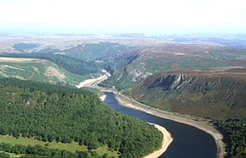
Northern end of the Garreg-ddu reservoir, looking north.
Photo: CPAT 03-C-0613.
|
|
|
|
|
|
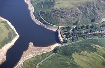 Craig Goch dam and reservoir at the head of the Elan valley, viewed from the south-west. Work on the Craig Goch dam began in 1897, three years after work had started on the Caban-coch, the lowest dam across the Elan.
Photo: CPAT 03-C-0620.
Craig Goch dam and reservoir at the head of the Elan valley, viewed from the south-west. Work on the Craig Goch dam began in 1897, three years after work had started on the Caban-coch, the lowest dam across the Elan.
Photo: CPAT 03-C-0620.
|
|
|
|
|
|
 Distant view of the Craig Goch dam.
Photo: CPAT 1528.23.
Distant view of the Craig Goch dam.
Photo: CPAT 1528.23.
|
|
|
|
|
|
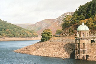 Foel valve tower with the Garreg-ddu reservoir, seen during a period of low water. Water from the Elan valley reservoirs begins its journey to Birmingham at the tower. The distinctive architectural style of the dams and valve towers in the Elan valley has been called ‘Birmingham Baroque’.
Photo: CPAT 1526.14.
Foel valve tower with the Garreg-ddu reservoir, seen during a period of low water. Water from the Elan valley reservoirs begins its journey to Birmingham at the tower. The distinctive architectural style of the dams and valve towers in the Elan valley has been called ‘Birmingham Baroque’.
Photo: CPAT 1526.14.
|
|
|
|
|
|
 Ancillary buildings and structures
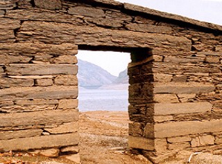
Part of the Visitor Centre below Caban-coch dam, occupying one of the former works buildings belonging to the Elan valley reservoir scheme.
Photo: CPAT 1538.08.
|
|
|
|
|
|
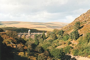
 From left to right: modern lakeside road, revetted course of former railway to the foot of the Penygarreg dam and revetted course of railway line to the Craig Coch dam, near the northern end of the Carreg-ddu reservoir.
Photo: CPAT 1540.01.
From left to right: modern lakeside road, revetted course of former railway to the foot of the Penygarreg dam and revetted course of railway line to the Craig Coch dam, near the northern end of the Carreg-ddu reservoir.
Photo: CPAT 1540.01.
|
|
|
|
|
|
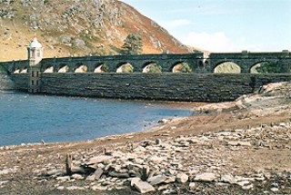
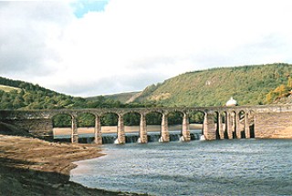 The Carreg-ddu viaduct with Caban-coch reservoir in the foreground, seen during a period of low water. The weir at the foot of the viaduct is normally hidden from view. The viaduct, used during the construction period to carry a railway line into the Claerwen valley, is today used for road traffic.
Photo: CPAT 1527.15.
The Carreg-ddu viaduct with Caban-coch reservoir in the foreground, seen during a period of low water. The weir at the foot of the viaduct is normally hidden from view. The viaduct, used during the construction period to carry a railway line into the Claerwen valley, is today used for road traffic.
Photo: CPAT 1527.15.
|
|
|
|
|
|
 Earlier landscapes normally hidden below the water
Distant view of Craig Goch dam from the south-east with Penygarreg reservoir in the foreground, seen during a period of low water. The remains of Ty-nant house, demolished to make way for the reservoir and normally submerged below the reservoir, are visible at the bottom left. In the far distance is Esgair Rhiwlan.
Photo: CPAT 1528.08.
|
|
|
|
|
|
 Craig Goch dam and domed valve tower, seen from the west during a period of low water. The stone platform and timber uprights of a workmen’s hut used during the construction of the dam, are visible in the foreground. The hut would have been similar to one still visible near the Elan Valley Visitor Centre. The arches along the top of the dam carry a narrow roadway.
Photo: CPAT 1528.34.
Craig Goch dam and domed valve tower, seen from the west during a period of low water. The stone platform and timber uprights of a workmen’s hut used during the construction of the dam, are visible in the foreground. The hut would have been similar to one still visible near the Elan Valley Visitor Centre. The arches along the top of the dam carry a narrow roadway.
Photo: CPAT 1528.34.
|
|
|
|
|
|
 Remains of the walled garden of the Nantgwyllt country house, visible during a period of low water. Caban-coch dam is visible in the distance.
Photo: CPAT 1539.13.
Remains of the walled garden of the Nantgwyllt country house, visible during a period of low water. Caban-coch dam is visible in the distance.
Photo: CPAT 1539.13.
|
|
|
|
|
