CPAT logo


Cymraeg / English
Back Home
Historic Landscapes

Historic Landscape Characterisation

Mynydd Hiraethog


The following description, taken from the Historic Landscapes Register, identifies the essential historic landscape themes in the historic character area.

Click for landscape description

Character areas defined in the Mynydd Hiraethog Historic Landscape


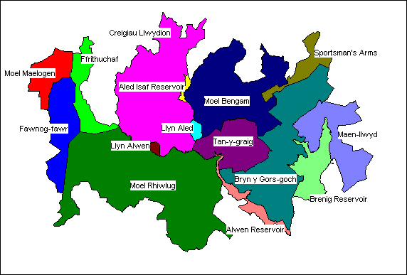
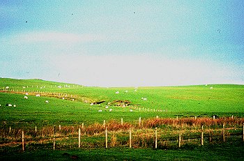
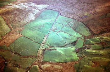
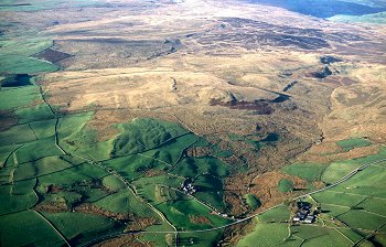
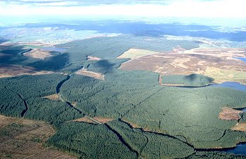
The Denbigh Moors (Mynydd Hiraethog) are situated at the northern end of the Cambrian Mountains and they comprise the southern, upland parts of the large, natural block of land lying between the two major river valleys of the Clwyd and the Conwy in North Wales. It is a bleak and deserted area of rolling moorland, generally between 400m and 500m above OD, but with several valleys cutting across the northern and eastern flanks to penetrate into the upland core. However, the area described here as a landscape is only the central and western parts of that upland massif, comprising a large, and in Wales and increasingly rare, survival of an uninterrupted extent of heather moorland that was deliberately managed and maintained as a grouse moor and a shooting estate in the early part of the 20th century. It has been selected to exclude most of the eastern part containing extensive forestry plantations that form part of Clocaenog Forest, which was originally similar to, and a continuation of, the area described here.

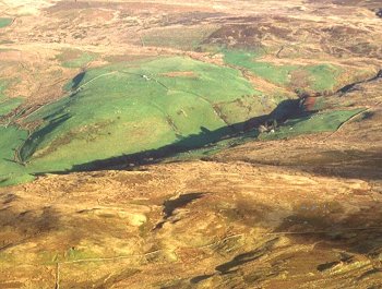
This moorland landscape, like many other upland areas of Wales, has its origins in the upland economies of the Neolithic and Bronze Age or, as recent interpretations of archaeological evidence from elsewhere in Britain suggest, possibly in the economy of the preceding Mesolithic period when it has been suggested that areas of the moorland might have been deliberately burnt and cleared for hunting. The prehistoric landscape of the uplands was modified subsequently through continued seasons of summer grazing, based on temporary summer settlements or hafodau sited in the valleys and along the edges of the moor. In times of population pressure or better climate, some of these sites might have been occupied on a permanent basis, and there are several hafod sites which had become permanently settled in the post-medieval period. Much of the area was subject to peat extraction in the last century, and the remains of cuts and drying stacks still about, as do the remains of the post-medieval farmsteads whose occupants had exploited the peat.

On the Denbigh Moors, this earlier landscape in turn was swept away, and is overlain by the remnants of a regime of managed heather moorland imposed on it in the early years of the 20th century. While this landscape is a relatively modern creation, the large uninterrupted extent surviving is none the less rare in Wales and therefore historically valuable; elsewhere much of this managed heather grouse moor has been done away with in the last 50 years.

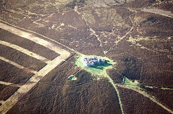
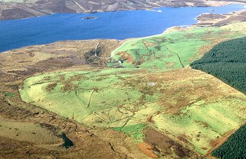
The landscape extent identified here has thus been selected to include these surviving blocks of heather moorland and also to reflect those surviving areas of land not so managed which lay outside this regime. Much of this survival is due to the creation of a shooting estate by Viscount Devonport between 1908 and 1925. Spread over much of the area are the remains of dug-out and drystone shooting butts and shelters, together with field walls, boundary markers and earthworks which probably date from this period. This area also boasts the ruined shooting box at Gwylfa Hiraethog, an elaborate lodge built in 1908–11 to accommodate shooting parties. The structure, which replaced an earlier timber lodge specially imported from Norway, and still known locally as Plas Pren, is reputed to have been the highest inhabited house in Wales and to have had the widest views of any house in Britain. The ruins still form a prominent landmark which are visible across the area from several directions.

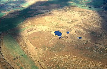
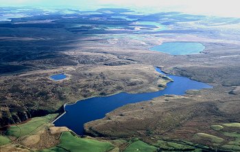
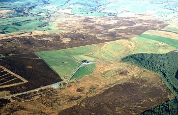
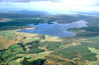
Each of the local summits within the landscape is topped by groups of Bronze Age burial cairns which presumably attest to wider activity at this time, the evidence of which is now masked by the modern landscape. There is no evidence for associated settlements, although groups of later, prehistoric type settlements have been found and recently archaeologically excavated in the excluded, eastern part of Hiraethog. The areas around Llyn Aled and Aled Isaf reservoir have yielded large quantities of worked flint dating from the Mesolithic period through to the Bronze Age.

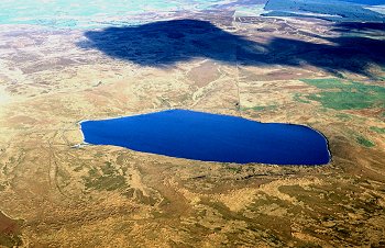
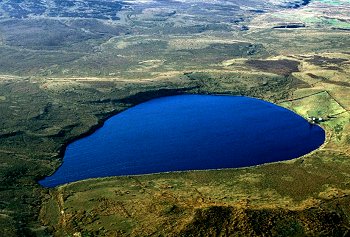
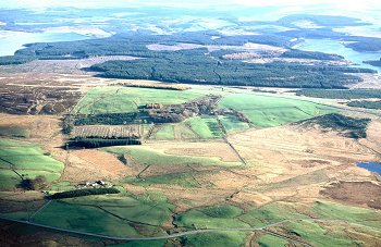
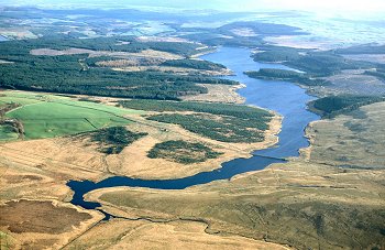
The Brenig reservoir, built between 1973 and 1976, and its surrounding forestry, which also contains a number of Bronze Age and post-medieval sites, dominates the landscape from the south. Many of the sites close to, or flooded by, the reservoir were excavated prior to its construction and a sample have now been reconstructed as part of an archaeological trail. The management of water resources is also an important theme in, and a function of Hiraethog described here, for the landscape contains the catchment for the earlier Alwen reservoir built between 1911 and 1916 to supply water to Birkenhead Corporation, and the smaller reservoirs of Llyn Aled and Llyn Aled Isaf built in the 1930s to supply water to the coastal holiday resort of Rhyl.

Historic landscape themes in Mynydd Hiraethog

The Natural Landscape

The Administrative Landscape

Settlement Landscapes

Landuse

Transport and Communications

Industrial Landscapes

Lakes, Reservoirs and Pools

Prehistoric, Burial and Ceremony

Conservation and Recreation

Character areas

CPAT PHOTO cs013138

1099 Moel Maelogen character area. Late 18th to early 19th-century enclosed and improved pasture on north-west edge of Mynydd Hiraethog. Photo: CPAT CS01-31-38 (back to map)


Click here for further information about this Historic Landscape Character area

Click here for character area map

CPAT PHOTO 01c215

1100 Ffrithuchaf character area. Unenclosed moorland on the northern edge of Mynydd Hiraethog, overlooking Gwytherin and the steep-sided valley of the Afon Cledwen. Photo: CPAT 01-C-215 (back to map)


Click here for further information about this Historic Landscape Character area

Click here for character area map

CPAT PHOTO 01c214

1101 Fawnog-fawr character area. Moorland on western edge of Mynydd Hiraethog, subdivided into large polygonal enclosures in the late 18th to early 19th century. Photo: CPAT 01-C-214 . (back to map)


Click here for further information about this Historic Landscape Character area

Click here for character area map

CPAT PHOTO 01c211

1102 Creigiau Llwydion character area. Unenclosed moorland on northern edge of Mynydd Hiraethog with discrete medieval and later encroachments. Photo: CPAT 01-C-211. (back to map)


Click here for further information about this Historic Landscape Character area

Click here for character area map

CPAT PHOTO 01c177

1103 Aled Isaf Reservoir character area. Modern reservoir fed by the Afon Aled in valley on northern edge of Mynydd Hiraethog. Photo: CPAT 01-C-177. (back to map)


Click here for further information about this Historic Landscape Character area

Click here for character area map

CPAT PHOTO 01c182

1104 Llyn Aled character area. Natural upland lake extended as reservoir in the earlier 20th century within the central moorland area of Mynydd Hiraethog. Photo: CPAT 01-C-182. (back to map)


Click here for further information about this Historic Landscape Character area

Click here for character area map

CPAT PHOTO 01c183

1105 Llyn Alwen character area. Natural upland lake in the central moorland area. Photo: CPAT 01-C-183. (back to map)


Click here for further information about this Historic Landscape Character area

Click here for character area map

CPAT PHOTO 01c217

1106 Moel Rhiwlug character area. Heather moorland subdivided polygonal enclosures in the later 18th or early 19th century and managed as part of shooting estate in later 19th and in 20th century, with scattered prehistoric funerary monuments and medieval and later seasonal settlement evidence. Photo: CPAT 01-C-217 . (back to map)


Click here for further information about this Historic Landscape Character area

Click here for character area map

CPAT PHOTO 01c190

1107 Moel Bengam character area. Unenclosed moorland, common land; sheepfolds, large round cairn, boundary markers on parish boundary and ruined Edwardian shooting lodge. Photo: CPAT 01-C-190. (back to map)


Click here for further information about this Historic Landscape Character area

Click here for character area map

CPAT PHOTO 01c168

1108 Tan-y-graig character area. Scattered post-medieval farmstead encroachments on sheltered south-facing slopes towards the southern edge of moor, some drained and improved land and small conifer plantations. Photo: CPAT 01-C-168. (back to map)


Click here for further information about this Historic Landscape Character area

Click here for character area map

CPAT PHOTO 01c192

1109 Sportsman’s Arms character area. Late 18th and early 19th-century enclosure of former common and inn along early 19th-century turnpike on northern edge of moor. Photo: CPAT 01-C-192. (back to map)


Click here for further information about this Historic Landscape Character area

Click here for character area map

CPAT PHOTO 01c156

1110 Bryn y Gors-goch character area. Modern coniferous forest plantation overlying relict medieval and later enclosed landscape of scattered farmsteads with associated field systems and stone quarrying. Photo: CPAT 01-C-156 . (back to map)


Click here for further information about this Historic Landscape Character area

Click here for character area map

CPAT PHOTO 01c170

1111 Alwen Reservoir character area. Earlier 20th-century reservoir superimposed upon medieval and later enclosed landscape. Photo: CPAT 01-C-170. (back to map)


Click here for further information about this Historic Landscape Character area

Click here for character area map

CPAT PHOTO 01c152

1112 Brenig Reservoir character area. Large later 20th-century reservoir in broad valley towards the eastern edge of Mynydd Hiraethog superimposed upon a medieval and later landscape of farmsteads and fields. Photo: CPAT 01-C-152 . (back to map)


Click here for further information about this Historic Landscape Character area

Click here for character area map

CPAT PHOTO 01c160

1113 Maen-llwyd character area. Heather moorland with some improved grassland, partly divided into large polygonal enclosures of 18th/19th century date, Bronze Age funerary and ritual landscape, enclosed medieval sheepcotes, medieval and later hafodydd and farmsteads, archaeological trail. Photo: CPAT 01-C-160. (back to map)


Click here for further information about this Historic Landscape Character area

Click here for character area map


For further information please contact the Clwyd-Powys Archaeological Trust at this address, or link to the Countryside Council for Wales' web site at www.ccw.gov.uk.


Privacy and cookies
1113 Maen-llwyd 1112 Brenig Reservoir 1112 Brenig Reservoir 1111 Alwen Reservoir 1111 Alwen Reservoir 1111 Alwen Reservoir 1111 Alwen Reservoir 1099 Moel Maelogen 1101 Fawnog-fawr 1103 Aled Isaf Reservoir 1105 Llyn Alwen 1100 Ffrithuchaf 1106 Moel Rhiwlug 1106 Moel Rhiwlug 1106 Moel Rhiwlug 1106 Moel Rhiwlug 1106 Moel Rhiwlug 1102 Creigiau Llwydion 1102 Creigiau Llwydion 1102 Creigiau Llwydion 1104 Llyn Aled 1104 Llyn Aled 1107 Moel Bengam 1107 Moel Bengam 1109 Sportsman's Arms 1108 Tan-y-graig 1108 Tan-y-graig 1108 Tan-y-graig 1108 Tan-y-graig 1108 Tan-y-graig 1110 Bryn y Gors-goch